Weather conditions across Cyprus are expected to remain mostly favourable through Friday, with plenty of sunshine. However, afternoon cloud build-up, mainly over mountainous and semi-mountainous areas and at times inland, is likely to continue producing isolated showers or thunderstorms in the coming days, according to Kitasweather.
At night, localised mist and low cloud are expected to form, particularly inland and along coastal areas. Temperatures are not expected to change significantly until Friday, remaining close to or slightly above seasonal averages, with inland highs reaching around 28 to 29 degrees Celsius.
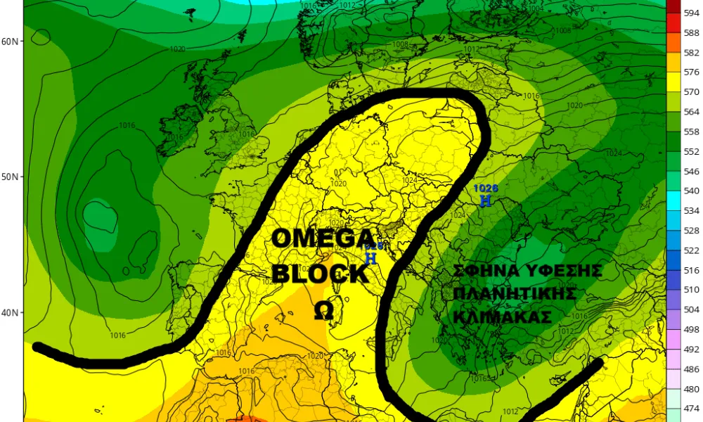
Towards the end of the week, an Omega Block is expected to form over Europe. This development is likely to increase the probability of rainfall in Cyprus and allow an unusually cold air mass to move into the region from Sunday night, leading to a noticeable drop in temperatures. There is also a possibility of sleet or temporary snowfall over the highest peaks of the Troodos Mountains.
What is an Omega Block?
According to Kitasweather, blocking patterns, also known as blocking highs, refer to large high-pressure systems that become established over a wide area and disrupt the typical west-to-east movement of weather systems.
An Omega Block is a specific type of blocking pattern, characterised by a dominant high-pressure system in the centre, flanked by low-pressure systems to the west and east. The resulting airflow in the middle and upper atmosphere takes on a shape resembling the Greek letter Omega.
Weather conditions vary depending on a location’s position within the pattern.
Areas located at the centre of the block, under the high-pressure system, typically experience settled conditions, light winds and generally higher-than-average daytime temperatures. However, clear skies and weak winds can also lead to strong temperature inversions at night, resulting in significantly lower minimum temperatures and a wide day-night temperature range.
By contrast, regions positioned to either side of the block tend to experience low-pressure conditions, bringing unsettled weather and temperatures that are often below average.
Such blocking patterns can persist for several days or even weeks, leading to prolonged dry conditions in areas under high pressure and above-average rainfall in regions affected by low pressure.
Detailed forecast
On Wednesday, a weak trough in the mid-level atmosphere continues to affect the region, while a colder-than-usual air mass over north-eastern Europe is beginning to move southwards towards the Balkans.
The day began with sunshine along with localised mist and low cloud, which have largely cleared across most areas. During the afternoon, cloud is expected to develop mainly over mountainous and semi-mountainous areas, and more locally inland, with the possibility of isolated showers or thunderstorms. Overnight, mist and low cloud are expected to reform in inland and coastal areas.
Temperatures will remain close to seasonal averages or slightly above, reaching around 26 to 29 degrees Celsius inland, 23 to 26 degrees along the coast and about 14 degrees at Chionistra.
On Thursday, after the dissipation of morning mist and low cloud, conditions will be mostly clear. During the afternoon, increased cloud over mountainous and semi-mountainous areas may again bring isolated showers or thunderstorms, mainly over higher ground. Mist and low cloud are expected to return overnight.
Temperatures will remain largely unchanged, with inland highs again reaching around 26 to 29 degrees Celsius, 23 to 26 degrees along the coast and about 14 degrees at Chionistra.
By Friday, the Omega Block will have formed over Europe, with a ridge extending across central-western Europe, while a trough and unusually cold air mass for the season extend from north-eastern Europe towards Greece, gradually moving further south.
Following the clearance of morning mist and low cloud, the weather will be mostly clear with some high cloud. During the afternoon, increased cloud is expected over mountainous and inland areas, as well as parts of the north and north-east, where isolated showers cannot be ruled out. Mist and low cloud are expected again overnight.
Temperatures will remain close to seasonal averages, reaching around 25 to 28 degrees inland, 23 to 25 degrees along the coast and around 13 degrees at Chionistra.
On Saturday, the Omega Block will persist over Europe, while the trough and the colder air mass continue to move towards the eastern Mediterranean, with the trough expected to cut off.
After morning mist and low cloud clear, conditions will initially be mostly clear with some high cloud. Gradually, cloud cover will increase, becoming partly to mostly cloudy, with the possibility of light rain, especially over mountainous areas later in the day. By the evening, conditions will become mostly cloudy, with occasional light rain.
Temperatures will fall slightly but remain close to seasonal averages, reaching around 24 to 27 degrees inland, 22 to 25 degrees along the coast and around 12 degrees at Chionistra.
From Sunday into Monday, a cut-off low in the mid-level atmosphere, along with a surface low-pressure system, is expected to affect Cyprus. This will bring scattered to localised showers, with a temporary intensification of rainfall late Sunday into early Monday, particularly affecting the western and south-western parts of the island.
Winds are also expected to strengthen from westerly directions from Sunday afternoon and especially on Monday.
At the same time, an unusually cold air mass for the season will move into the region from Sunday night into Monday, resulting in a marked drop in temperatures to well below seasonal norms. Due to this development, there is a possibility of sleet or temporary snowfall over the highest peaks of the Troodos Mountains, mainly from Sunday night into early Monday.